


Como Twp. Voting District, Marshall County, Minnesota
About
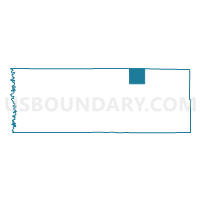
Outline

Summary
| Unique Area Identifier | 603044 |
| Name | Como Twp. Voting District |
| County | Marshall County |
| State | Minnesota |
| Area (square miles) | 36.32 |
| Land Area (square miles) | 36.32 |
| Water Area (square miles) | 0.00 |
| % of Land Area | 100.00 |
| % of Water Area | 0.00 |
| Latitude of the Internal Point | 48.50029880 |
| Longtitude of the Internal Point | -96.05946600 |
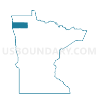
Maps

Graphs
Select a template below for downloading or customizing gragh for Como Twp. Voting District, Marshall County, Minnesota


Neighbors
Neighoring Voting District (by Name) Neighboring Voting District on the Map
- Cedar Twp. Voting District, Marshall County, MN
- Deer Twp. Voting District, Roseau County, MN
- Huntly Twp. Voting District, Marshall County, MN
- Huss Twp. Voting District, Roseau County, MN
- Poplar Grove Twp. Voting District, Roseau County, MN
- Spruce Valley Twp. Voting District, Marshall County, MN
- Thief Lake Twp. Voting District, Marshall County, MN
- Whiteford Twp. Voting District, Marshall County, MN
Top 10 Neighboring County Subdivision (by Population) Neighboring County Subdivision on the Map
- Spruce Valley township, Marshall County, MN (242)
- Huss township, Roseau County, MN (120)
- Deer township, Roseau County, MN (105)
- Cedar township, Marshall County, MN (86)
- Poplar Grove township, Roseau County, MN (82)
- Huntly township, Marshall County, MN (77)
- Whiteford township, Marshall County, MN (44)
- Como township, Marshall County, MN (39)
- Thief Lake township, Marshall County, MN (39)